GEOTECHNICALENGINEERING
SURREY
HomeUnderground ExcavationsGeotechnical design of deep excavations

Geotechnical Design of Deep Excavations in Surrey, BC: Managing Soft Soils and High Groundwater

Technical studies that support your project.

LEARN MORE

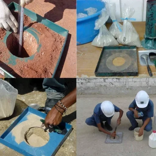
The contrast between Surrey’s upland neighborhoods like Fleetwood and the low-lying floodplains of the Nicomekl River defines the city’s excavation challenges. In South Surrey, dense glacial till can stand vertically for short periods, but move north toward the Fraser River and you encounter 15 to 25 meters of soft, normally consolidated silts and clays with undrained shear strengths below 30 kPa. Designing a deep excavation here demands more than standard shoring tables; it requires a site-specific model calibrated to pore pressure dissipation rates and seasonal groundwater fluctuations that routinely reach within 1.5 meters of ground surface. For temporary support in these sensitive soils, the slope stability analysis workflow integrates directly with our excavation models to verify global stability during staged cuts.

In Surrey’s soft soil zones, the difference between a successful excavation and a costly setback often comes down to the accuracy of the initial pore pressure model.

Our service areas

Our approach and scope

A typical deep excavation project in Surrey starts with a truck-mounted hollow stem auger rig and a set of electronic piezometers installed weeks before the shoring design is finalized. We use automated settlement pins and inclinometer casings around the perimeter of the dig, tracking lateral deformations at 0.5-meter vertical intervals through the soft upper clays. The design iteration runs on finite element or finite difference software—Plaxis 2D or FLAC—where we input the modified Cam-Clay parameters derived from consolidated undrained triaxial tests on Shelby tube samples. This is not a one-size-fits-all approach: the compressibility of the overconsolidated crust in Cloverdale behaves differently from the organic silts near Mud Bay. Every excavation sequence is phased, with the temporary berm dimensions and strut preloads specified to keep adjacent road settlements under the 25 mm threshold accepted by the City of Surrey engineering department.
Geotechnical Design of Deep Excavations in Surrey, BC: Managing Soft Soils and High Groundwater
Technical reference — Surrey

Local ground factors

A 14-story mixed-use excavation at 104 Avenue and King George Boulevard hit an unmapped pocket of peat at 6 meters depth that the preliminary boreholes missed. The soldier pile wall started rotating, with recorded deflections exceeding 40 mm at the crest within three days. The contractor halted excavation, and we mobilized overnight to install additional tieback anchors at two levels and a 1.5-meter-thick stabilizing berm at the toe. The root cause was an interpolation gap in the geotechnical baseline report—the peat lens was only 4 meters wide but ran parallel to the wall for 12 meters. This case reshaped our approach to baseline reporting in Surrey: we now insist on a maximum borehole spacing of 15 meters in the Nicomekl and Serpentine floodplain zones, not the standard 25 meters, and we run cone penetration tests between boreholes to catch organic inclusions that a standard rotary drill might smear through.

Need a geotechnical assessment?

Reply within 24h.

Email: [email protected]

Reference standards

NBCC 2020 – Division B, Part 4 (Structural Design) – seismic load provisions for earth retaining structures, CSA A23.3-19 – Design of Concrete Structures – Chapter 14 (cast-in-place foundation walls and secant piles), City of Surrey Development Cost Charges (DCC) Bylaw – Section 4.3 (adjacent settlement limits), ASTM D7181 – Standard Test Method for Consolidated Drained Triaxial Compression Test for Soils (used for effective stress parameters in Plaxis), CFEM (Canadian Foundation Engineering Manual) 4th Edition – Chapter 26 (deep excavations and earth support systems)

Technical parameters

ParameterTypical value
Maximum excavation depth analyzedUp to 25 m below grade
Typical soil profile (lowland Surrey)Soft silty clay (CH) over dense till
Undrained shear strength (Su) at 5 m depth18–35 kPa (Nicomekl/Serpentine areas)
Seasonal groundwater level (north Surrey)1.2–1.8 m below ground surface
Primary shoring systems designedSecant pile, soldier pile & lagging, diaphragm wall
Design standard for structural concreteCSA A23.3-19
Seismic load case methodologyNBCC 2020, Mononobe-Okabe pseudo-static
Maximum allowable adjacent settlement25 mm (per City of Surrey DCC requirements)

Frequently asked questions

Does the City of Surrey require a geotechnical design report for deep excavations deeper than 4.5 meters?

Yes. Under the Surrey Building Bylaw and BC Building Code, any excavation deeper than 4.5 meters or within 1.2 meters of a property line requires a sealed geotechnical design report. The report must address lateral earth pressures, groundwater control, adjacent foundation protection, and construction sequencing. The City's Development Engineering section reviews the shoring design as part of the building permit process, and they commonly request an independent third-party review for excavations exceeding 10 meters.

What soil parameters do you use for finite element modeling of Surrey's Fraser River clays?

We derive parameters from consolidated undrained triaxial tests (ASTM D4767) on undisturbed Shelby tube samples, typically yielding modified Cam-Clay parameters: λ (compression index) of 0.18–0.25, κ (swelling index) of 0.02–0.04, and Μ (critical state friction parameter) of 1.20–1.35. The overconsolidation ratio in Surrey's soft clays usually ranges from 1.0 to 1.4 below 5 meters depth, except in the desiccated crust where it can reach 3.0.

How do you handle seismic design for deep excavation shoring in a high-seismicity zone like Surrey?

We apply the NBCC 2020 seismic hazard values for Surrey (Site Class D or E depending on the profile) and use a Mononobe-Okabe pseudo-static approach for the earth pressure increment. The horizontal seismic coefficient kh is typically taken as 0.5 × the peak ground acceleration for the 2,475-year return period, which for Surrey locations can range from 0.15 to 0.22g depending on the specific site coordinates. The water table position is critical—we assume full saturation behind the wall for the seismic load case unless positive drainage is installed and maintained.

What is the typical cost range for geotechnical design of a deep excavation in Surrey?

For a typical multi-level excavation in Surrey—say 8 to 15 meters deep with a secant pile or soldier pile wall—the geotechnical design package, including the baseline report, finite element modeling, shoring calcs, and construction-phase monitoring plan, generally falls between CA$3,240 and CA$12,070 depending on the complexity of the soil profile, the number of retained sides, and whether an independent peer review is required by the City. Projects with complex tieback geometries or instrumented test sections push toward the upper end of that range.

Location and service area

We serve projects in Surrey and surrounding areas.

View larger map